
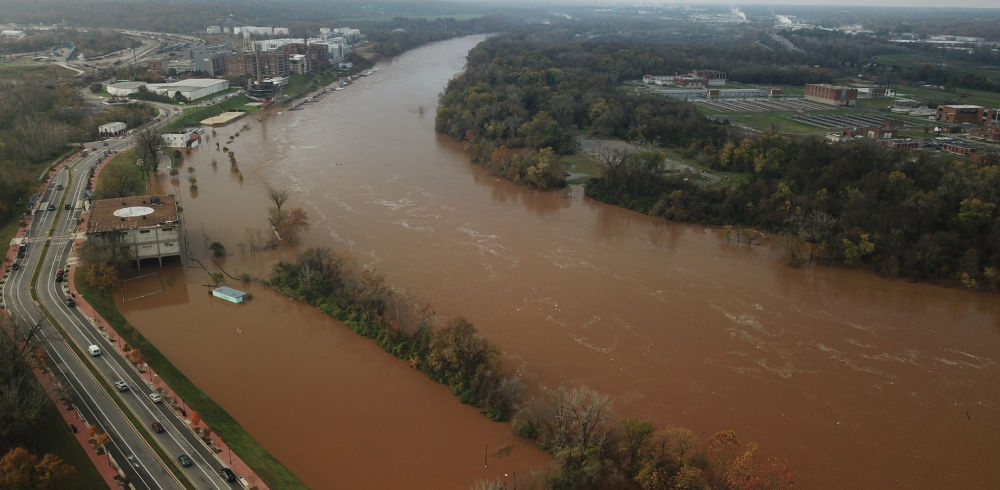
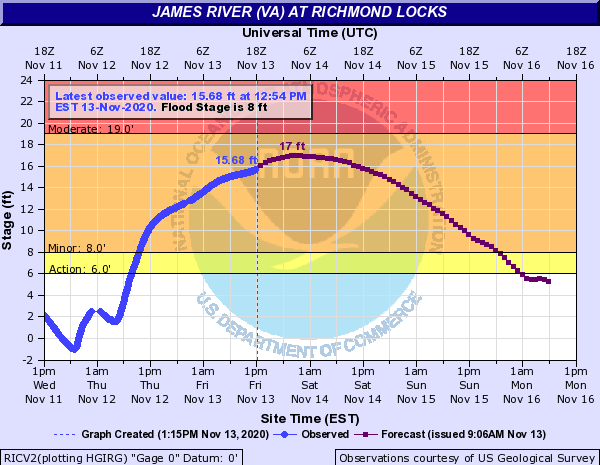
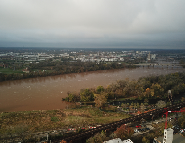
The James River is forecast to crest around 17’ at the Richmond Locks gauge located at Great Shiplock Park tonight. The last time the James River crested above 17’ at the Richmond Locks gauge was almost two decades ago in 2003. While 17’ is significant, it is well below the more memorable crests of the 20th Century.

Recent river flooding has me reflecting on historic James River crests. Historically, tropical systems have been the catalysts for historic crests on the James River. In fact, the top three crests in Richmond were the result of tropical systems.
Historic James River Crests at the Richmond Locks Gauge:
|
Rank |
Event |
Date |
Crest (feet) |
|
1 |
Hurricane Agnes |
6/23/72 |
36.5 |
|
2 |
Hurricane Juan (Election Day Flood) |
11/7/85 |
30.76 |
|
3 |
Hurricane Camille |
8/22/69 |
28.6 |
Source: National Weather Service Advanced Hydrologic Prediction Service
Hurricane Agnes
Hurricane Agnes made landfall in the United States near Panama City, Florida on June 19, 1972. The tropical system drenched the eastern United States and flooded Shockoe Bottom and Manchester in Richmond, Virginia. Richmond’s Mayo Island and Mayor Bridge were inundated. The James River crested at 36.5 feet in Richmond on June 23. Thirteen fatalities and over $125 million in losses were reported in Virginia.
Hurricane Juan (Election Day Flood)
The remnants of Hurricane Juan combined with another low-pressure system and dropped significant rainfall across the Appalachian Mountains and Mid-Atlantic in late October 1985. The James River crested at 30.76 feet and flooded several blocks of Downtown Richmond on November 7. President Ronald Reagan signed legislation authorizing the construction of Richmond’s floodwall the following year.
Hurricane Camille
Hurricane Camille, a Category 5 hurricane, made landfall near the mouth of the Mississippi River on August 17, 1969. On the evening of August 19 and 20, the remnants of Camille crossed the Appalachian Mountains and devastated Nelson County, Virginia. Flash floods, mudslides, and debris flows significantly altered the landscape of Nelson County overnight. Rainfall in excess of 27 inches, mostly falling in a five-hour period, overwhelmed the James River and its tributaries. The James River crested at 41.3 feet at Columbia and 28.6 feet at Richmond. 153 people died and numerous roads, bridges, and structures were damaged or destroyed. Damage totaled more than $140 million and Virginia was declared a disaster area.
I have been following high water events on the James River for the better part of a decade. Today’s flood event is the highest I have ever seen the James in Richmond and it gave me a better appreciation of the historic floods of 1969, 1972, and 1985.

Justin Doyle is the James River Association’s Community Conservation Manager and resides in Richmond, Virginia. The James River Association’s Community Conservation Program promotes conservation and responsible stewardship of our natural resources and helps communities realize the benefits of a healthy James River.