Living Shoreline Cost Share Program
Financial & technical support to help waterfront homeowners install living shorelines.


What is a Living Shoreline?
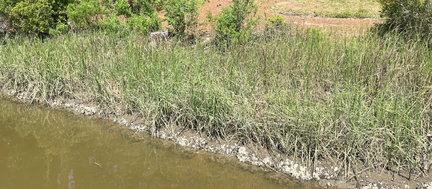
Living shorelines represent a nature-based approach to stabilizing waterfront property. Unlike traditional hard structures like bulkheads, these shorelines utilize native plants and rock to mimic natural coastal defenses. Additionally, they are designed to grow and pivot with the river over time, thereby increasing long-term resilience.
Why choose a living shoreline?
Effective Erosion Control
These systems stabilize your shoreline by absorbing wave energy rather than reflecting it.
Improved Water Quality
The native plants act as a filter; therefore, they trap polluted runoff before it enters the river.
Thriving Wildlife Habitat
Because they use natural materials, they create essential homes for crabs, fish, and birds.
Increased Resilience
Additionally, living shorelines can adapt to rising sea levels over time, unlike static concrete walls.
What We Provide
For eligible homeowners, our program covers:
- Free Site Visit: Expert assessment of your shoreline.
- Project Design: Professional design services at no cost.
- Permitting Assistance: We help navigate the permit process.
- Financial Support: Coverage of 75% of construction costs.
- Maintenance: Three years of post-construction maintenance support.
Eligibility Requirements
To qualify for the program, you must:
- Location: Own property within the lower James River watershed (Check our map below).
- Need: Have a tidal shoreline that is currently eroding or at risk.
- Commitment: Agree to maintain the living shoreline for at least 10 years.
- Contribution: Be able to provide the remaining 25% of construction costs.
Is our Living Shoreline Cost Share program right for your property??
While living shorelines are the preferred method for stabilizing tidal shorelines in Virginia, they are not a “one-size-fits-all” solution. For instance, certain environmental or geographical factors may affect your eligibility for our cost-share funding.
Factors That May Limit Eligibility
Your property might not be a candidate for the JRA Cost Share program if it includes:
High Eroding Bluffs
These are common on the south bank of the James River and often require different engineering than a standard living shoreline.
Non-Tidal Locations
Our program is designed for tidal waters. Properties along inland creeks, deep woods streams, or non-tidal lakes usually do not qualify.
Sensitive Habitats
If your shoreline is immediately adjacent to protected submerged aquatic vegetation (SAV) or other highly sensitive habitats, construction may be restricted.
Accessibility Issues
If your shoreline is immediately adjacent to protected submerged aquatic vegetation (SAV) or other highly sensitive habitats, construction may be restricted.
Not sure if you qualify?
If you are unsure about your site, please contact Ryan Walsh, Senior Coastal Restoration Manager, at rwalsh@thejamesriver.org. Alternatively, you can use the map to check your location within the watershed.
How to Apply
Check Eligibility
Review the watershed map to ensure your property is located within the eligible service area.
Submit an Interest Form
Fill out our online interest form. You will need to provide your property address and details about your current shoreline erosion.
Site Consultation
If eligible, a JRA staff member will contact you to schedule a site visit. We will assess your shoreline and discuss the best design options for your property.
What to Expect: Your Project Timeline
Because we work with natural growing seasons and regulatory agencies, the process typically takes 12 to 18 months. However, the long-term benefits for your property are well worth the wait.
Phase 1: Assessment & Design (Months 1–4)
First, once your interest form is approved, our team conducts a detailed site assessment. We look at fetch (wave energy), bank height, and existing vegetation in order to create a custom design that will thrive on your specific stretch of the river.
Phase 2: Permitting (Months 4–10)
Subsequently, the project enters the permitting phase, which is often the longest stage. During this time, JRA handles the heavy lifting by coordinating with local wetlands boards, the Virginia Marine Resources Commission (VMRC), and the Army Corps of Engineers to ensure your project meets all environmental regulations.
Phase 3: Construction & Planting (Months 10–14)
Once permits are secured, construction usually begins during specific “windows” that protect local fish and wildlife. Specifically, after structural elements like stone sills or coir logs are placed, we plant native marsh grasses during their optimal growing season.
Phase 4: Growth & Stewardship (Years 1–3)
Finally, it is important to remember that a living shoreline is a “living” system. Therefore, for the first three years, we provide ongoing maintenance support to ensure the native plants take root and the shoreline stabilizes effectively.

If your property is not located in the James River watershed, or if you do not qualify for our specific program, other resources are available.
Virginia Conservation Assistance Program (VCAP)
VCAP is an urban cost-share program for property owners in specific Soil and Water Conservation Districts. It provides financial incentives for “Best Management Practices,” including living shorelines.
- Administrator: Virginia Soil and Water Conservation Districts.
- Learn More: vaswcd.org/vcap
Elizabeth River Project (River Star Homes)
Homeowners in the Elizabeth River watershed may be eligible for the River Star Homes program.
- Offer: Pays up to 50% of costs (up to $4,000) for living shoreline projects.
- Contact: (757) 399-7487 or visit elizabethriver.org
Shoreline Erosion Advisory Service (SEAS)
SEAS provides free technical advice and written reports for eroding shorelines statewide.
- Administrator: Department of Conservation and Recreation (DCR).
- Service: Advisory only https://www.dcr.virginia.gov/soil-and-water/seas
Restoring the Riverbank
Read more about two success stories from our Living Shoreline Cost Share Program.
A Sustainable Solution for Brewers Creek
John Curry spent a decade watching his Brewers Creek property in Carrollton erode. He initially considered a concrete bulkhead, but the permitting process proved too costly and complex. However, after connecting with the James River Association’s Cost-Share Program, John discovered a nature-based alternative.
Completed in 2019, the living shoreline has successfully halted erosion while creating a vibrant habitat where John can now watch oysters thrive.
“I had no idea this much help was available. The teams at the James River Association and Bay Environmental were great and I enjoy going down to see what’s hanging out in the water.” – John Curry, Carrollton, VA
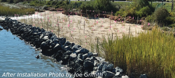
Community-Led Restoration in Phoebus
Joe Griffith and the Phoebus Partnership saw an opportunity to revitalize the underused Phoebus Waterfront Park. The park’s existing shoreline was failing, and experienced frequent flooding. In response, volunteers worked alongside technical experts to expand the park’s planted buffer.
For Joe, the project was a major learning experience. As a result, the park now serves as a community-led model for flood resilience, showing how nature-based defenses can protect public spaces.
In the end, they are out here doing this. That’s what it’s all about. I can tell that they care about this place.” — Joe Griffith, Phoebus Neighborhood Association